
Page 22 - Garmin_Marine
P. 22
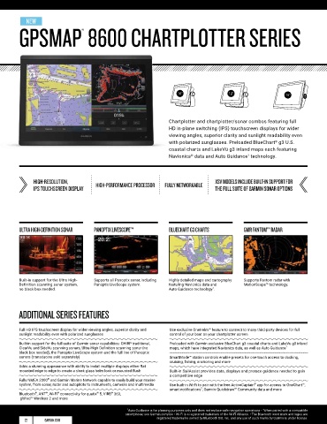
NEW
GPSMAP 8600 CHARTPLOTTER SERIES GPSMAP 702/902 & 1202 TOUCH SERIES
®
10" 12" 16" 7" 9" 12"
Chartplotter and chartplotter/sonar combos featuring full Networking chartplotters and chartplotter/sonar combos
HD in-plane switching (IPS) touchscreen displays for wider with touchscreen controls, traditional and scanning sonar
viewing angles, superior clarity and sunlight readability even capabilities , preloaded BlueChart g3 U.S. coastal charts and
1
®
with polarized sunglasses. Preloaded BlueChart g3 U.S. LakeVü g3 inland maps each featuring Navionics data and
®
®
coastal charts and LakeVü g3 inland maps each featuring Auto Guidance technology.
2
Navionics data and Auto Guidance technology.
1
®
HIGH-RESOLUTION, HIGH-PERFORMANCE PROCESSOR FULLY NETWORKABLE XSV MODELS INCLUDE BUILT-IN SUPPORT FOR SUNLIGHT-READABLE XS MODELS INCLUDE 1 KW CHIRP TRADITIONAL PRELOADED WITH BLUECHART G3
IPS TOUCHSCREEN DISPLAY THE FULL SUITE OF GARMIN SONAR OPTIONS FULLY NETWORKABLE AND CLEARVÜ SCANNING SONAR, XSV MODELS
TOUCHSCREEN DISPLAY AND LAKEVU G3 CARTOGRAPHY
ADD SIDEVÜ SCANNING SONAR
ULTRA HIGH-DEFINITION SONAR PANOPTIX LIVESCOPE™ BLUECHART G3 CHARTS GMR FANTOM™ RADAR DIGITAL SWITCHING SUPPORT PANOPTIX LIVESCOPE™ GMR FANTOM™ RADAR BLUECHART G3 CHARTS
Built-in support for the Ultra High- Supports all Panoptix sonar, including Highly detailed maps and cartography Supports Fantom radar with Nearly all your controls are available Supports all Panoptix sonar, including Supports Fantom radar with Highly detailed maps and cartography
Definition scanning sonar system, Panoptix LiveScope system. featuring Navionics data and MotionScope™ technology. right at your fingertips. Panoptix LiveScope. MotionScope™ technology. featuring Navionics data and
no black box needed. Auto Guidance technology . 1 Auto Guidance technology . 2
ADDITIONAL SERIES FEATURES ADDITIONAL SERIES FEATURES
®
Full HD IPS touchscreen display for wider viewing angles, superior clarity and Use exclusive OneHelm™ feature to connect to many third-party devices for full Bright, easy-to-use sunlight-readable touchscreen display Supports FUSION-Link™ audio system and VIRB camera streaming
sunlight readability even with polarized sunglasses control of your boat on your chartplotter screen
Preloaded with Garmin exclusive BlueChart g3 coastal charts and LakeVü g3 inland Network sharing allows you to share data with all compatible units connected to
Built-in support for the full suite of Garmin sonar capabilities: CHIRP traditional, Preloaded with Garmin exclusive BlueChart g3 coastal charts and LakeVu g3 inland maps, which have integrated Navionics data, as well as Auto Guidance 1 the network
ClearVu and SideVu scanning sonars, Ultra-High Definition scanning sonar (no maps, which have integrated Navionics data, as well as Auto Guidance 1
black box needed), the Panoptix LiveScope system and the full line of Panoptix XS models feature built-in support for 1 kW single-channel CHIRP sonar and Built-in Wi-Fi pairs with the free ActiveCaptain app for access to OneChart™,
®
®
sonars (transducers sold separately) SmartMode™ station controls enable presets for one-touch access to docking, ClearVü scanning sonar transducers (sold separately) which allows purchase and download of new charts plus access to smart
2
cruising, fishing, anchoring and more notifications , software updates, Garmin Quickdraw™ Community data and more
Adds a stunning appearance with ability to install multiple displays either flat XSV models add support for SideVü scanning sonar and support transducers
mounted edge to edge to create a sleek glass helm look or mounted flush Built-in SailAssist provides data, displays and prerace guidance needed to gain (sold separately) Includes Quickdraw Contours mapping software to create custom maps with 1’
a competitive edge contours as you fish (optional sonar transducer required)
®
Fully NMEA 2000 and Garmin Marine Network capable to easily build your marine Support for Panoptix™ all-seeing sonar, premium Garmin sonar modules and a wide
system, from sonar, radar and autopilots to instruments, cameras and multimedia Use built-in Wi-Fi to pair with the free ActiveCaptain app for access to OneChart™, range of transducers (sold separately) Built-in Garmin SailAssist™ features, including laylines, race features, set and drift,
®
smart notifications , Garmin Quickdraw™ Community data and more wind data and more
2
®
®
Bluetooth , ANT , Wi-Fi connectivity for quatix 5, VIRB 360, Fully network capable to build your marine system, from radar, autopilot, sonar modules
®
®
®
gWind™ Wireless 2 and more and sensors to Axis and FLIR thermal cameras and GXM™ 53 marine weather receiver Built-in 10 Hz GPS with a refresh rate of 10 times per second
1 Auto Guidance is for planning purposes only and does not replace safe navigation operations • 2 When paired with a compatible
smartphone; see Garmin.com/ble • Wi-Fi is a registered trademark of the Wi-Fi Alliance. • The Bluetooth word mark and logos are 1 When paired with a compatible mobile device; see Garmin.com/ble • Auto Guidance is for planning purposes only and does not
2
22 GARMIN.COM registered trademarks owned by Bluetooth SIG, Inc. and any use of such marks by Garmin is under license. replace safe navigation operations • Wi-Fi is a registered trademark of the Wi-Fi Alliance. GARMIN.COM 23