
Page 57 - Garmin_Marine
P. 57
GPSMAP HANDHELDS INREACH SERIES
®
®
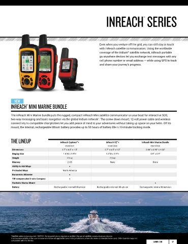
Even when you venture off the grid, you can still stay in touch
GPSMAP 276CX with inReach satellite communicators. Using the worldwide
®
coverage of the Iridium satellite network, inReach portable
®
All-terrain navigator with advanced GPS and GLONASS reception go-anywhere devices let you exchange text messages with any
tracks your position in challenging environments. It has a large, cell phone number or email address — while using GPS to track
sunlight-readable 5” screen plus built-in barometric altimeter and and share your journey’s progress.
3-axis compass. The GPSMAP 276CX also comes preloaded with
a worldwide basemap and free 1-year BirdsEye Satellite Imagery
subscription. Advanced mapping, connectivity and flexible
mounting options are available; and it's water-rated to IPX7.
It pairs with your compatible mobile device for automatic
1
uploads, smart notifications and more; also compatible with
Wi-Fi and ANT+ technology for integration of external sensors.
®
®
NEW
GPS 73 AND GPSMAP 78 SERIES HANDHELDS INREACH MINI MARINE BUNDLE
®
®
Boaters and watersport enthusiasts everywhere swear by The inReach Mini Marine bundle puts the rugged, compact inReach Mini satellite communicator on your boat for interactive SOS,
GPSMAP 73 and 78 handhelds. They float! The 78 series features two-way messaging and basic navigation via the global Iridium network . The screw down mount, 12-volt power cable and wireless
1
bright 2.6” LCD color displays with built-in worldwide basemaps connectivity to compatible chartplotters let you add peace of mind to your adventures without taking up space on your helm. Off its
and a special MOB (man overboard) button. The GPS 73 includes mount, the internal, rechargeable lithium battery provides up to 50 hours of battery life in 10-minute tracking mode.
SailAssist features, including virtual starting line, heading line,
countdown timers and tack assist.
THE LINEUP inReach Explorer + inReach SE + inReach Mini Marine Bundle
®
®
010-01735-11 010-01735-00 010-01879-00
Dimensions 2.7" x 6.5" x 1.5" 2.7” x 6.5” x 1.5” 2.04” x 3.90” x 1.03”
Display Size 1.4"W x 1.9"H 1.4”W x 1.9”H 0.9” x 0.9”
Weight 7.5 oz 7.5 oz
Memory 2 GB None None
Ability to Add Maps •
THE LINEUP GPSMAP 73 GPSMAP 78 GPSMAP 78s GPSMAP 78sc Preloaded Maps North America
010-01504-00 010-00864-00 010-00864-01 010-00864-02 Barometric Altimeter •
Easy-to-use Handheld • • • • Tilt-compensated 3-axis Compass •
Floats • • • • Hardwire Marine Mount •
SailAssist • Battery Rechargeable internal lithium-ion Rechargeable internal lithium-ion Rechargeable internal lithium-ion
Back-lit Buttons • • • •
Color Screen • • •
Worldwide Basemap • • Built-in BlueChart g2
Ability to Add Maps • • •
Waypoints/Favorites/Locations 1,000 2,000 2,000 2,000
Routes 50 200 200 200
Memory/History 1.7 GB 1.7 GB 1.7 GB
Battery Life 18 hours 20 hours 20 hours 20 hours
Compass Tilt-compensated 3-axis Tilt-compensated 3-axis
Barometric Altimeter • •
1 Satellite subscription required • NOTICE: Some jurisdictions regulate or prohibit the use of satellite communications devices.
It is the responsibility of the user to know and follow all applicable laws in the jurisdictions where the device is intended to be used. Other Garmin maps not
1 See Garmin.com/ble • Wi-Fi is a registered trademark of the Wi-Fi Alliance. compatible with this device.
56 GARMIN.COM GARMIN.COM 57