
Page 15 - Garmin_Inland
P. 15
LakeVü HD Series Sonar Technology
DETAILED MAPS THAT HELP FIND FISH
With mapping detail so precise - down to 1’ contours, it gives you valuable insight into bottom structure, helping you pinpoint exactly where to drop your
line. Find submerged riverbeds, bridges and other fish attractors as well as potential hazards. You’ll also have shoreline features like dock outlines,
Cartography & Apps
campgrounds, boat ramps, marinas and much more. Coverage of over 17,000 lakes and waterways in the US and over 13,500 in Canada, you’re sure to
have what you need at your fingertips for a successful day on the water.
LAKEVÜ HD US AND LAKEVÜ HD CANADA
LakeVü HD US and LakeVü HD Canada are Garmin’s advanced freshwater map offerings, covering US and Canada, providing precise detail and features that
Software & Features
are reliable and easy to use.
LAKEVÜ HD ULTRA US AND LAKEVÜ HD ULTRA CANADA
LakeVü HD Ultra US and LakeVü HD Ultra Canada are Garmin’s premium freshwater map offerings, covering US and Canada, bringing in all the reliability
and features of LakeVü HD while adding industry leading features like AutoGuidance and Fishing Hot Spots Pro.
LAKEVÜ FEATURES Chartplotters & Combos
LakeVü HD Ultra 3 LakeVü HD Ultra 3 LakeVü HD Ultra 1 LakeVü HD 1
LakeVü HD Ultra 1 LakeVü HD Ultra 1 LakeVü HD Ultra 1
Fishfinders
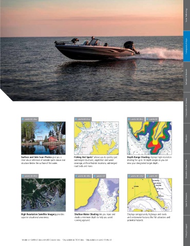
Surface and Side Scan Photos give you a Fishing Hot Spots allows you to quickly spot Depth Range Shading displays high-resolution
®
Auto Guidance directs you to your hot spots High Resolution Relief Shading adds visual Dynamic Lake Level allows you to adjust your clear visual reference of notable spots above and submerged structures, vegetation and weed shading for up to 10 depth ranges so you can
by creating a suggested route on screen for your depth to the 2D map making it easier to interpret maps to the lake’s current water levels giving you structure below the surface of the water. coverage, artificial habitat locations, submerged view your designated target depth.
boat that seeks to avoid shallow water and other contours and find fish holding structure. a better idea of spots that are either accessible or road beds and more.
charted obstructions. too shallow to explore. Wearables & Handhelds
LakeVü HD Ultra 3 LakeVü HD Ultra 1 LakeVü HD 1 LakeVü HD Ultra 3 LakeVü HD 3
LakeVü HD Ultra 1 LakeVü HD Ultra 2 LakeVü HD Ultra 1 LakeVü HD 1
Specs & Networks
High Resolution Satellite Imagery provides Shallow Water Shading lets you input and Displays campgrounds, highways and roads
superior situational awareness. shade a minimum depth to help you avoid and underwater features like fish attractors and
MarinersEye View provides a 3D Sonar Imagery shows a nearly photographic 1’ Contours provide a detailed and clear view
representation of the surrounding area both view of the bottom, as if all the water had been of the the lake floor so you can catch more fish running aground. potential hazards.
above and below the waterline. FishEye View drained away. and navigate with confidence.
shows 3D representation of lake bottom and
contours as seen from below the waterline. Pricing & Support
1 Included on 13,000 U.S. lakes and 4,800 Canadian lakes 2 Only available on 700 US lakes 3 Only available on LakeVü HD Ultra US
12 GARMIN.COM