
Page 17 - Garmin_Inland
P. 17
Sonar Technology
BlueChart g2 HD BlueChart g2 Vision HD Series
®
®
®
Know The Oceans Below You
®
Our exclusive marine cartography includes detailed nautical charts derived from government charts and private sources. They will BlueChart Features
enable you to see your vessel’s precise position, on-chart, in relation to navaids, spot soundings, coastal features, anchorages, port plans, water-
g2 Vision HD g2 HD g2 Vision HD g2 HD g2 Vision HD g2 HD
ways, obstructions, restricted areas and more, in a seamless chart presentation. Coverage is available worldwide, in regional offerings, for Garmin Cartography & Apps
handhelds and chartplotters.
BlueChart g2 HD
®
BlueChart g2 HD is Garmin’s advanced chart offering, providing worldwide cartography information and features that are reliable and easy to use. Software & Features
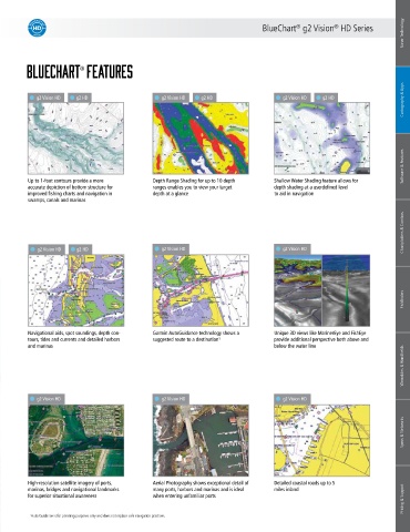
Up to 1-foot contours provide a more Depth Range Shading for up to 10 depth Shallow Water Shading feature allows for
BlueChart g2 Vision HD accurate depiction of bottom structure for ranges enables you to view your target depth shading at a userdefined level
®
®
improved fishing charts and navigation in
to aid in navigation
depth at a glance
swamps, canals and marinas
BlueChart g2 Vision HD is Garmin’s premium chart offering, bringing all the reliability and features of BlueChart g2 HD while adding in industry leading
Chartplotters & Combos
features, like AutoGuidance.
g2 Vision HD g2 HD g2 Vision HD g2 Vision HD
Fishfinders
Navigational aids, spot soundings, depth con- Garmin AutoGuidance technology shows a Unique 3D views like MarinerEye and FishEye
tours, tides and currents and detailed harbors suggested route to a destination¹ provide additional perspective both above and
and marinas below the water line
Wearables & Handhelds
g2 Vision HD g2 Vision HD g2 Vision HD
Specs & Networks
High-resolution satellite imagery of ports, Aerial Photography shows exceptional detail of Detailed coastal roads up to 5
Pricing & Support
marinas, bridges and navigational landmarks many ports, harbors and marinas and is ideal miles inland
for superior situational awareness when entering unfamiliar ports
1 Auto Guidance is for planning purposes only and does not replace safe navigation practices.