
Page 12 - Garmin_Marine
P. 12
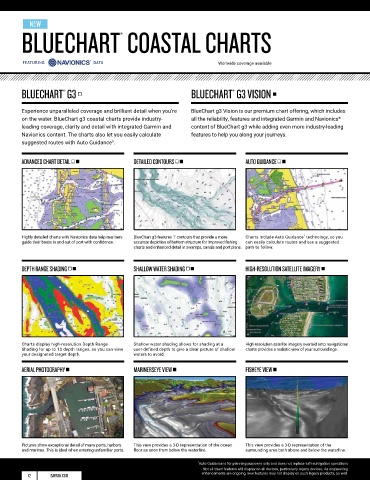
NEW                                                                                                                                                                                                                          NEW
        BLUECHART COASTAL CHARTS                                                                                                                                                  LAKEVÜ INLAND MAPS
                                         ®


                                                                         Worlwide coverage available


        BLUECHART  G3      •                                    BLUECHART  G3 VISION       •                                       LAKEVÜ G3    •                                          LAKEVÜ G3 ULTRA      •
                                                                              ®
                      ®
        Experience unparalleled coverage and brilliant detail when you’re   BlueChart g3 Vision is our premium chart offering, which includes   LakeVü g3 inland maps provide industry-leading coverage,   LakeVü g3 Ultra is our premium inland map collection
        on the water. BlueChart g3 coastal charts provide industry-  all the reliability, features and integrated Garmin and Navionics    clarity and detail with integrated Garmin and Navionics    providing all the industry-leading features of LakeVü g3,
                                                                                                                 ®
                                                                                                                                                                               ®
        leading coverage, clarity and detail with integrated Garmin and   content of BlueChart g3 while adding even more industry-leading   content. The charts also let you easily calculate suggested   including integrated Garmin and Navionics content, while
        Navionics content. The charts also let you easily calculate   features to help you along your journeys.                    routes with Auto Guidance . You'll get coverage on more than   adding more than 1,500 MaxDef lakes and more than 150
                                                                                                                                                        1
        suggested routes with Auto Guidance .                                                                                      17,000 lakes with up to 1’ contours.                    Garmin Elite Survey Lakes.
                                      1
        ADVANCED CHART DETAIL • •            DETAILED CONTOURS • •                AUTO GUIDANCE • •                                1' CONTOURS • •                      AUTO GUIDANCE • •                    DEPTH RANGE SHADING • •


                                                                                                     1
        Highly detailed charts with Navionics data help mariners   BlueChart g3 features 1' contours that provide a more   Charts include Auto Guidance  technology, so you   1' contours provide a detailed and clear view of the   Auto Guidance  technology allows you to easily   High-resolution Depth Range Shading displays
                                                                                                                                                                                 1
        guide their boats in and out of port with confidence.  accurate depiction of bottom structure for improved fishing   can easily calculate routes and see a suggested   the lake floor so you can catch more fish and navigate   calculate routes and see a suggested path to follow.  up to 10 depth ranges so you can view your
                                             charts and enhanced detail in swamps, canals and port plans.  path to follow.         with confidence.                                                          designated target depth.
        DEPTH RANGE SHADING • •              SHALLOW WATER SHADING • •            HIGH-RESOLUTION SATELLITE IMAGERY •              SHALLOW WATER SHADING • •            HIGH-RESOLUTION RELIEF SHADING •     SONAR IMAGERY •


        Charts display high-resolution Depth Range   Shallow water shading allows for shading at a   High-resolution satellite imagery overlaid onto navigational   Shallow water shading allows for shading at a   Relief shading adds visual depth to the 2-D map,   Sonar imagery shows a nearly photographic view of
        Shading for up to 10 depth ranges, so you can view   user-defined depth to give a clear picture of shallow   charts provides a realistic view of your surroundings.  user-defined depth to give a clear picture of shallow   making it easier to interpret contours and find fish   the bottom, as if all the water had been drained away.
        your designated target depth.        waters to avoid.                                                                      waters to avoid.                     holding structure.

        AERIAL PHOTOGRAPHY •                 MARINERSEYE VIEW •                   FISHEYE VIEW  •                                  DYNAMIC LAKE LEVEL •                 HIGH-RESOLUTION SATELLITE IMAGERY •  3-D VIEWS •


        Pictures show exceptional detail of many ports, harbors   This view provides a 3-D representation of the ocean   This view provides a 3-D representation of the   Adjust your maps to the lake’s current water levels to   High-resolution satellite imagery provides superior   MarinersEye and FishEye views provide 3-D representations
        and marinas. This is ideal when entering unfamiliar ports.  floor as seen from below the waterline.  surrounding area both above and below the waterline.  see if spots are accessible or to shallow to explore.   situational awareness.  of the surrounding area above and below the waterline.

                                                                  1 Auto Guidance is for planning purposes only and does not replace safe navigation operations
                                                                    Not all chart features will display on all devices, particularly legacy devices. As engineering    1
          12      GARMIN.COM                                        enhancements are ongoing, new features may not display on such legacy products, as well.  Auto Guidance is for planning purposes only and does not replace safe navigation operations  GARMIN.COM  13