
Page 14 - Garmin_Marine
P. 14
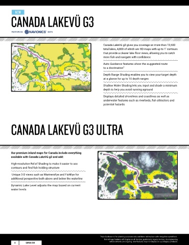
NEW
        CANADA LAKEVÜ G3                                                                                                                                                               ACTIVECAPTAIN APP
                                                                                                                                                                                                                                  ®


         featuring              data


                                                                    Canada LakeVü g3 gives you coverage on more than 13,500                                                                Give yourself the advantages of the ultimate connected boating
                                                                    total lakes, 4,800 of which are HD maps with up to 1’ contours                                                         experience. Download the free all-in-one ActiveCaptain app.
                                                                    that provide a clearer lake floor views, allowing you to catch                                                         It provides you with a powerful connection to your Garmin
                                                                    more fish and navigate with confidence                                                                                 chartplotter, charts, maps and the community. Wherever you are,
                                                                                                                                                                                           you can have unlimited access to your cartography, purchase
                                                                    Auto Guidance features show the suggested route                                                                        new maps and charts, and access the Garmin Quickdraw™
                                                                    to a destination 1                                                                                                     Contours Community.
                                                                    Depth Range Shading enables you to view your target depth
                                                                    at a glance for up to 10 depth ranges

                                                                    Shallow Water Shading lets you input and shade a minimum
                                                                    depth to help you avoid running aground

                                                                    Displays detailed shorelines and coastlines as well as
                                                                    underwater features such as riverbeds, fish attractors and
                                                                    potential hazards
                                                                                                                                   SPECIAL ACTIVECAPTAIN FEATURES


                                                                                                                                   OneChart™ gives you access to all your charts and maps from
                                                                                                                                   your mobile device and lets you purchase new ones
        CANADA LAKEVÜ G3 ULTRA                                                                                                     Receive smart notifications, such as calls and texts, on your


                                                                                                                                   chartplotter display when paired with the app

                                                                                                                                   Download software updates and notifications from the app
                                                                                                                                   directly to your Garmin devices

                                                                                                                                   Connect to fellow boaters with the ActiveCaptain community for
        Our premium inland maps for Canada include everything                                                                      up-to-date feedback on marinas and other points of interest
        available with Canada LakeVü g3 and add:
                                                                                                                                   Make, save and transfer routes and waypoints between the
        High-resolution Relief Shading to make it easier to see                                                                    app and chartplotter — with zero button presses 1
        contours and find fish holding structure
                                                                                                                                   Easily upload and download the latest Garmin Quickdraw™
         Unique 3-D views such as MarinersEye and FishEye for                                                                      Contours content from the community — with zero button presses 1
        additional perspective both above and below the waterline
                                                                                                                                   View and control your chartplotter from your smartphone or tablet
        Dynamic Lake Level adjusts the map based on current
        water levels


                                                                  1 Auto Guidance is for planning purposes only and does not replace safe navigation operations .
                                                                     Not all map features will display on all devices, particularly legacy devices. As engineering   ®
          14      GARMIN.COM                                            enhancements are ongoing, new features may not display on such legacy products.  ¹Zero button presses applies to GPSMAP  chartplotters                 GARMIN.COM   15